Change Monitoring (CM)
You may have access to some or all analytics layers, depending on your permissions.
If you do not have access to analytics layers, a message displays in the Analytics panel, informing you that analytics layers are unavailable. Contact support@vantor.com or call 1-800-496-1225 (Option 3) to obtain authorization for these layers.
Change Monitoring (CM) is a multi-temporal change detection technology that employs Vantor’s patented Correlated Land Change algorithm. CM layers allow decision makers, geospatial data providers, and geospatial data analysts to:
-
Identify, monitor, and anticipate change across the globe.
-
Prioritize resources to update critical geospatial infrastructure.
-
Understand the location, extent, time frame, and rates of land use and land cover change in a cost-effective and efficient manner.
CM offers the best value for a wide range of geospatial projects, such as supporting mapping, detecting change over time, monitoring assets, responding to disasters, providing humanitarian efforts, and more.
CM uses commercial moderate-resolution imagery to detect persistent land surface change while minimizing seasonal change and false positives. The multi-date pattern recognition process is used to discern and map anthropomorphic and natural land surface change on a pixel-by-pixel basis. The process is entirely automated and uses medium-resolution imagery from the Landsat, Sentinel-2, and Sentinel-1 constellations. The resulting data provide analysts with a powerful tipping and cueing mechanism for further research with high-resolution imagery or other assets, reducing both time and costs when updating geospatial assets.
Available Change Monitoring (CM) Layers
The following CM layers are available in Hub:
-
CM EO Electro-Optical Change Monitoring. This layer shows change in an area from 2010–2025.
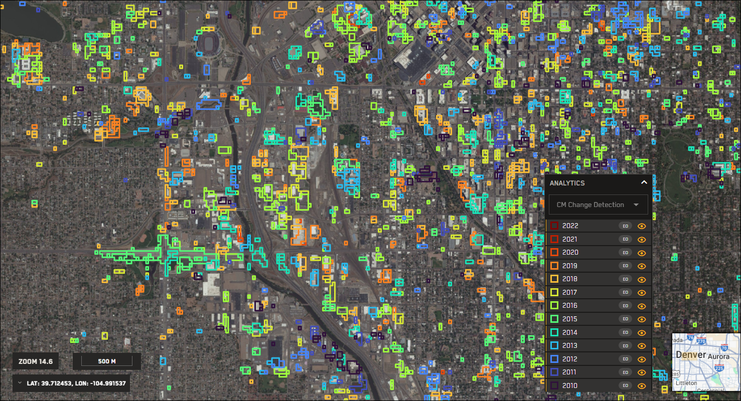
An example of CM EO change detection polygons over downtown Denver.
 More Information
There are two types of satellite images in this layer:
-
Landsat CM (30 m) uses a multi-temporal stack of precision, co-registered multispectral satellite images from the Landsat constellation. The dataset is a comprehensive historical account of land surface changes.
-
Sentinel CM (10 m) uses a multi-temporal stack of precision, co-registered multispectral satellite images from Sentinel 2A/2B. The near-global dataset accounts for land surface changes from the period of 2015 to present.
-
-
CM SAR (20 m) Synthetic Aperture Radar Change Monitoring. This layer shows change in an area from 2014-2025.
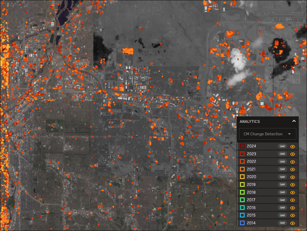
An example of CM SAR change polygons over downtown Denver and its western suburbs.
More Information
This layer is based on a multi-temporal stack of Sentinel 1A/1B GRDH Interferometric Wide Swath (IW) data. The satellites have day and night, all-weather imaging capabilities, and acquire imagery with a 250 km swath width at
The technology is ideal for persistent surface texture changes, especially the identification of new construction/destruction, deforestation/reforestation, and man-made changes. CM-SAR employs a historical baseline to minimize the effects of naturally occurring seasonal changes.
Visualizing Change in Hub
When working in Hub, you can identify change using the CM heatmap and change detection polygons, which indicate levels of change in an area.
-
Heatmap A summary of change in an area during a specific year. When viewing CM layers, the heatmap displays colored rectangles to indicate levels of change during the specified month or year. Change levels are indicated using a ROYGBV scale. Cooler colors (e.g., violet, blue) indicate lower levels of change, while warmer colors (e.g., yellow, orange, red) indicate higher levels of change. The CM heatmap is visible at zoom levels 10.9 and below.
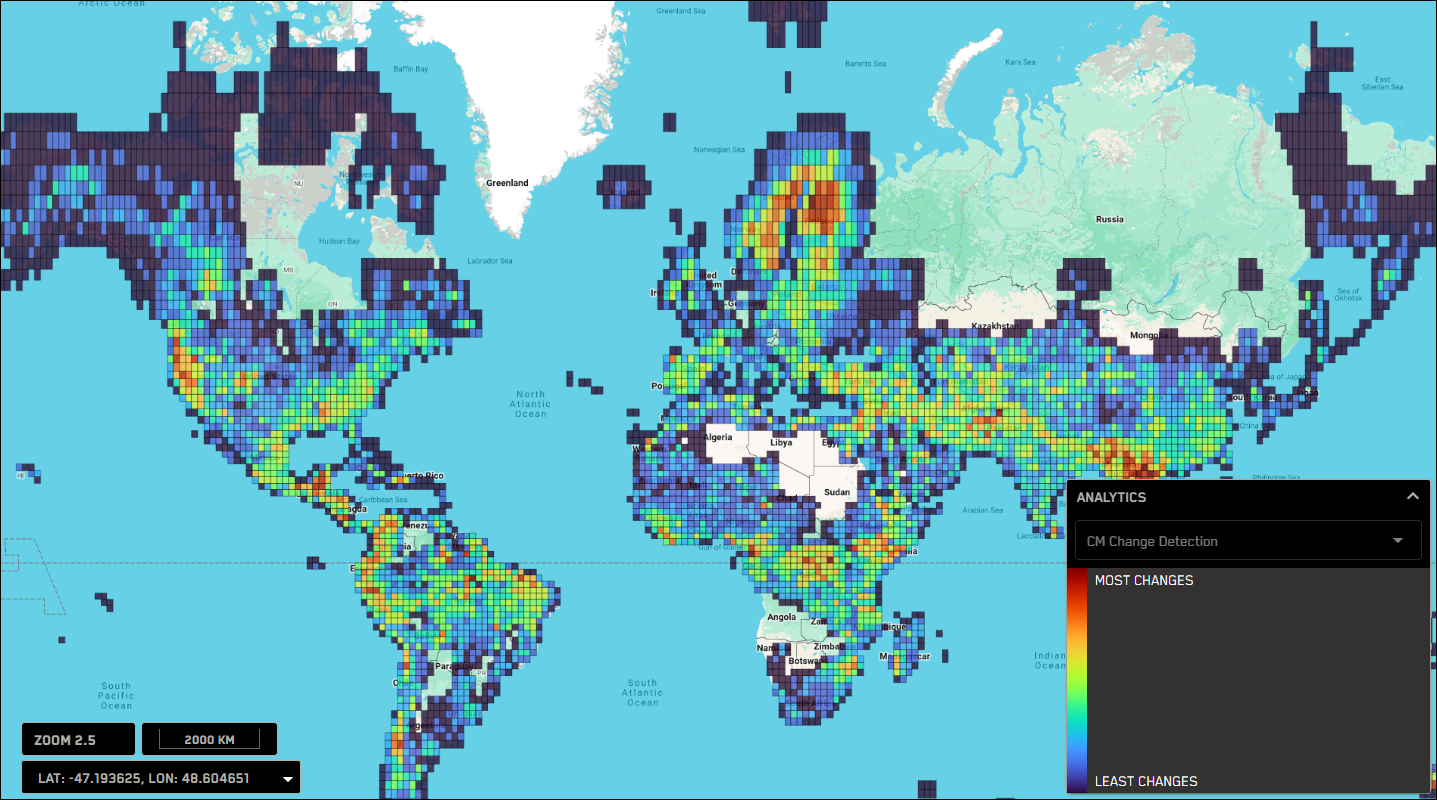
An example CM heatmap. The legend in the bottom-right corner of the page helps to identify levels of change over time.
-
Change Detection Polygons A specific area where change occurred. The color of each polygon represents the month or year of the change; these colors are identified in the Detection Layers legend in the Analytics panel. Change detection polygons are visible at zoom level 11.0 and higher.
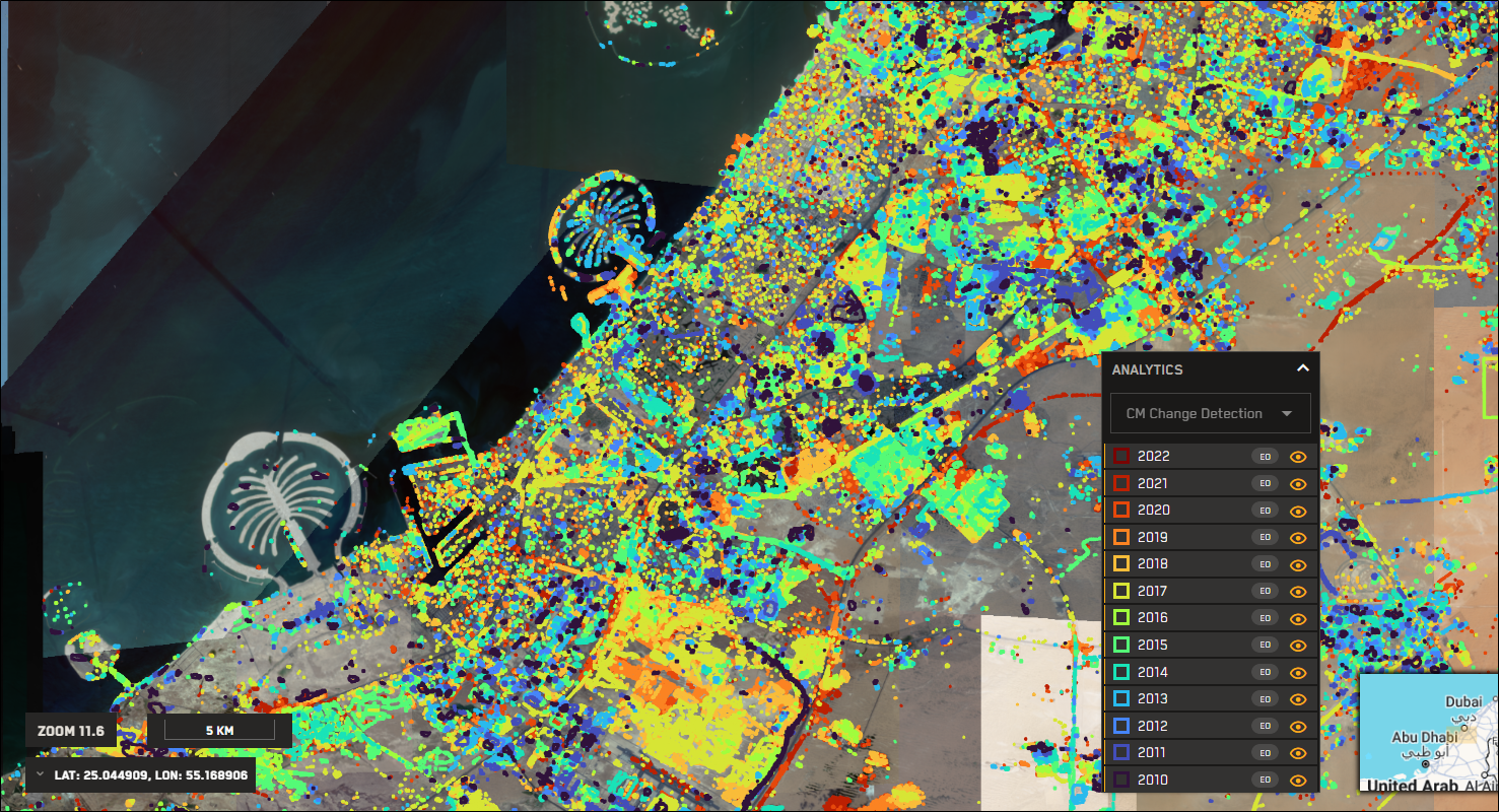
An example of change detection polygons, shown on a yearly basis.
Using Change Monitoring (CM) Layers
Use one or more CM layers to identify areas where change has occurred.
-
In the Analytics panel, do the following:
-
Select the CM layer you want to view. The default heatmap and the Analytics legend display.
-
From the Time Scale drop-down, select whether you want to view change on a monthly or yearly basis.
CM layers are updated monthly.
-
(Optional) Select additional CM layer options, if available.
-
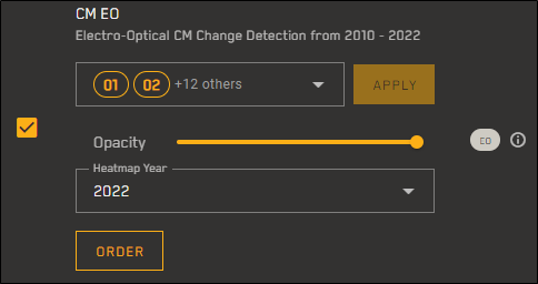
CM EO From the CAM Code drop-down, select the checkbox(es) for the Change Attribute Majority (CAM) codes you want to view, then select Apply.
 More Information
CAM Codes are used to distinguish and identify types of change, such as cultural changes vs. vegetated changes. Select one or more specific CAM codes to narrow down your results.
-
01 Cultural Change, or Non-Water/Non-Shadow Change
-
02 Probable Flood-Related Change
-
03 Probable Shadow Change
-
04 Probable Land-to-Water Change
-
05 Probable Water Oscillation
-
06 Probable Water-to-Land Change
-
07 Probable Seasonal Vegetation
-
11 Vegetated Change
-
12 Vegetated Probable Flood-Related Change
-
13 Vegetated Probably Flood Shadow Change
-
14 Vegetated Probable Land-to-Water Change
-
15 Vegetated Probable Water Oscillation
-
16 Vegetated Water-to-Land Change
-
17 Probable Seasonal Vegetation
-
-
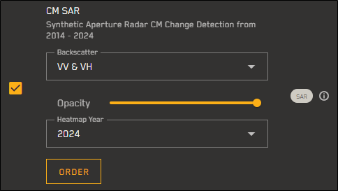
CM SAR From the Backscatter drop-down, select the backscatter polarization filtering you want to apply.
 More Information
Orientation of the plane in which transmitted electromagnetic waves oscillate. The first letter refers to the transmission orientation and the second letter refers to the reception orientation. H stands for horizontal, and V stands for vertical.
-
Only VV Vertical transmission and vertical reception
-
Only VH Vertical transmission and horizontal reception
-
VV and VH Vertical transmission and vertical reception and vertical transmission and horizontal reception
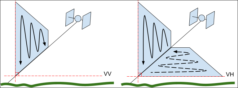
SAR signals are transmitted and received either vertically (V) or horizontally (H). Image credit: Alaska Satellite Facility
-
-
-
(Optional) Adjust the selected layer's opacity using the Opacity slider.
-
-
Zoom to level 13 or higher. Change detection polygons appear in the viewport.
By default, detection layers are toggled on for all


-
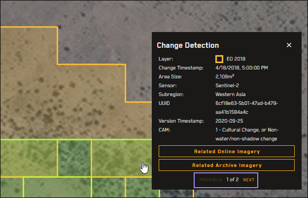
Select any polygon to see more details about the change(s) in that area, such as a timestamp, the area of the change polygon, the sensor, the layer name, the CAM code
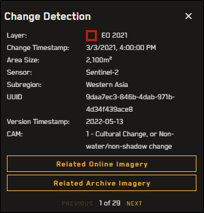
Additional details about a change polygon.
If there is more than one
-
(Optional) To view imagery related to the detection, in the detection pop-up, select Related Online Imagery or Related Archive Imagery.
When viewing imagery related to
-
If the change is newer than all of the available imagery, the newest image that intersects the object detection is selected.
-
If the change is older than all of the available imagery, the oldest image that intersects the object detection is selected.
-
If no imagery is available, or if no imagery intersects the change, you will see an error.
-
If you are trying to view related imagery in the online catalog, but you initially selected a detection area that is two years old or older, you may see an error that no imagery is available.
Imagery is automatically removed from the online catalog after a certain amount of time. If you encounter this error, try selecting a more recent detection area (i.e., less than two years old), or try searching for related imagery in the archive catalog.
-
-