Viewing Elevation
As you zoom and pan around the viewport, you can view the elevation at your cursor's current location in the viewport. You can also copy elevation data to use in third-party tools or for easy reference.
Viewing Your Current Elevation
-
Position your cursor over the area where you want to view elevation. The elevation data for that location displays in the

Copying Elevation Data
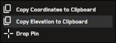
You can copy any location's elevation directly from the viewport. Copied elevation data can be used in third-party software tools.
-
Right-click any location in the viewport.
-
From the context menu, select Copy Elevation to Clipboard.
More About Elevation
-
Most of the world uses SRTM 30m post spacing for elevation data. SRTM 30m post spacing is a near-global digital elevation model (DEM) comprising a combination of data from the Shuttle Radar Topography Mission and the the U.S. Geological Survey's GTOPO30 data set.
For more information about SRTM 30m post spacing, please refer to ICESAT - SRTM30 Documentation.